


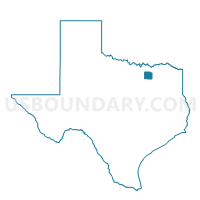
Voting District 0022, Collin County, Texas
About
Outline

Summary
| Unique Area Identifier | 671553 |
| Name | Voting District 0022 |
| County | Collin County |
| State | Texas |
| Area (square miles) | 58.58 |
| Land Area (square miles) | 57.67 |
| Water Area (square miles) | 0.91 |
| % of Land Area | 98.45 |
| % of Water Area | 1.55 |
| Latitude of the Internal Point | 33.34021410 |
| Longtitude of the Internal Point | -96.76255240 |
Maps


Graphs
Select a template below for downloading or customizing gragh for Voting District 0022, Collin County, Texas


Neighbors
Neighoring Voting District (by Name) Neighboring Voting District on the Map
- Voting District 0013, Collin County, TX
- Voting District 0020, Collin County, TX
- Voting District 0029, Collin County, TX
- Voting District 0031, Grayson County, TX
- Voting District 0033, Grayson County, TX
- Voting District 0100, Denton County, TX
- Voting District 0101, Denton County, TX
Top 10 Neighboring County Subdivision (by Population) Neighboring County Subdivision on the Map
- Pilot Point-Aubrey CCD, Denton County, TX (77,826)
- Celina CCD, Collin County, TX (20,403)
- Anna CCD, Collin County, TX (18,953)
- Southwest Grayson CCD, Grayson County, TX (10,515)
Top 10 Neighboring Place (by Population) Neighboring Place on the Map
Top 10 Neighboring Unified School District (by Population) Neighboring Unified School District on the Map
- McKinney Independent School District, TX (111,017)
- Celina Independent School District, TX (8,828)
- Pilot Point Independent School District, TX (8,041)
- Gunter Independent School District, TX (2,955)
Top 10 Neighboring State Legislative District Lower Chamber (by Population) Neighboring State Legislative District Lower Chamber on the Map
- State House District 70, TX (300,801)
- State House District 89, TX (253,976)
- State House District 63, TX (218,386)
- State House District 62, TX (154,792)
Top 10 Neighboring State Legislative District Upper Chamber (by Population) Neighboring State Legislative District Upper Chamber on the Map
Top 10 Neighboring 111th Congressional District (by Population) Neighboring 111th Congressional District on the Map
Top 10 Neighboring Census Tract (by Population) Neighboring Census Tract on the Map
- Census Tract 19, Grayson County, TX (10,515)
- Census Tract 303.05, Collin County, TX (8,391)
- Census Tract 201.04, Denton County, TX (3,216)
- Census Tract 302.02, Collin County, TX (2,250)